WALK INFORMATION:
DATES: 17th December 2021
DISTANCE: 16.6km
WEATHER: Perfect.
This was (yet) another rather hastily organised trip that often happens a) on a Friday and b) when the weather is good.
We had thought maybe a quick overnighter and another attempt on Mount Ida would be worth it, but after thinking about how’d we do it it all got a bit too complicated.
Thus, the idea of a visit to Florentine Peak was born.
I fondly remembered reading a post from RockMonkeyAdventures about a trip to Florentine, Tyenna and Mawson and Florentine Peak seemed very doable in a day where I knew I’d be starting later than I’d hope.
Why? Well, I’d convinced my dad to come too! Good to have some company, but we’re rarely away on time.
Anyway, we set off (later than I’d hoped) and drove the relatively short drive up to Lake Dobson in the Mount Field National Park.
We were up the track and past the ski village nice and quickly, and the awesome Mount Field views began.
Wasn’t long after than than Clive went the wrong way. Classic Clive.
Thankfully not as bad as usual. :)
We continued to amble along, soaking in the warm weather.
We climbed up onto the Rodway Range, and I briefly split off from Dad, making a quick line to the Rodway Range high point.
It’s not super easy to find, but it seems like I got there on the GPS track and I’m pretty sure I found the highest point!
There’s some lovely views over the valley to the west and you get a nice view of Florentine Peak and Tyenna Peak.
Instead of backtracking, I followed the range along and dropped back down to the main track just after the Lion’s Den.
We then slowly made out way down off the range, to K Col and the memorial hut.
Clive took a few stumbles, which I managed to capture!
We walked around to Clemes Tarn, and I grabbed some lunch.
We’d had the fortune of camping here several years back when we went up Mount Field West. I never wrote that trip up, and revisiting the tarn reminded me to see if I could find any old photos.
I often wonder why I like to write up trips, and I think it’s just a nice simple way of organising my thoughts from the walk and making sure the photos and maps are all in one spot if I ever want to read back.
And sometimes a reminder to look back pays off! I found the photos from the walk - we did it almost exactly three years ago.
The walk up from Clemes Tarn is pretty easy. Open and low scrub. There’s even a pretty easy pad to follow.
Just aim for the low side of the boulder field. You don’t need to walk on the boulders.
As I walked along, the weather was great and the views fantastic.
It wasn’t long before I was climbing up a steep slope from the saddle, up onto the high ground that makes up the area surrounding Florentine Peak.
Eventually, and much more quickly than I thought, I was on the top!
The views were - as usual - wonderful.
I tried to pick out a few peaks, and quickly saw some old friends off in the distance.
I took a quick panorama of the area, and slowly made my way back to try and catch up with Dad.
I caught him just before the board walk, as you walk back to the ski village.
We decided to take a slight detour over to the ski slopes. It’s a good way to go, as there’s pretty even track and it’s slightly different from the walk up.
I realised that the Mt Mawson webcam would be taking its hourly shot in about 9 minutes, so I waited around to try and get a cheery photo.
I thought it’d be taking it a few seconds before the top of the clock, so I checked the time and with about a minute to go, I held my arm up in a big wave and waited….
I stood like that for about two and a bit minutes, with the arm tiring as the clock counted up. I thought, ‘it’ll be worth it. A nice cheery photo!’
Turns out, the photo was taken as I was checking the time! Two minutes wasted. But I did get a photo of me looking like an idiot, so I suppose I got what I was going for in the end.
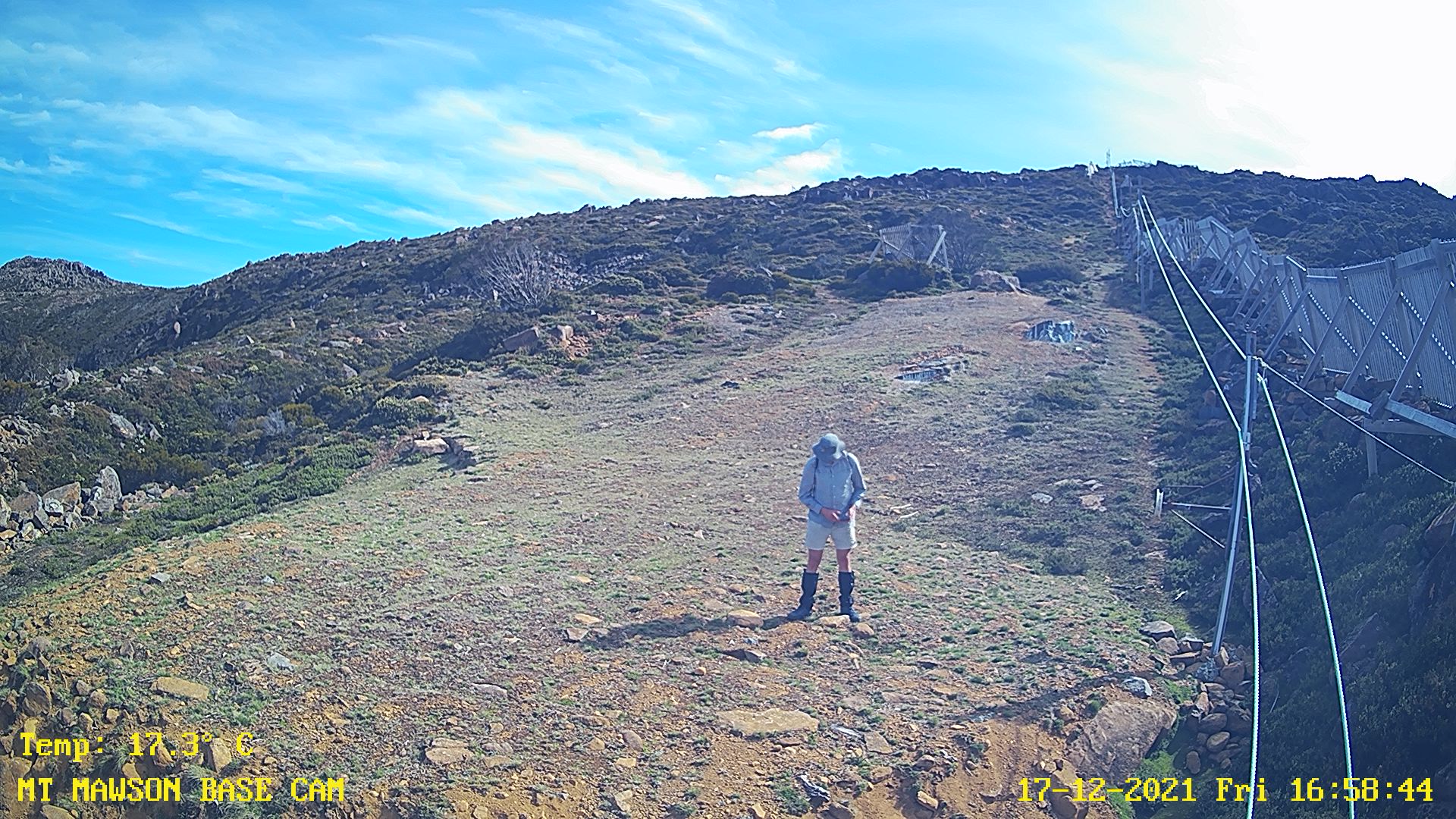
I’ll try again, one of these days :)
Trip Map
All up, 16.6km across 6 hours and 20 minutes. Total ascent about 935 meters.
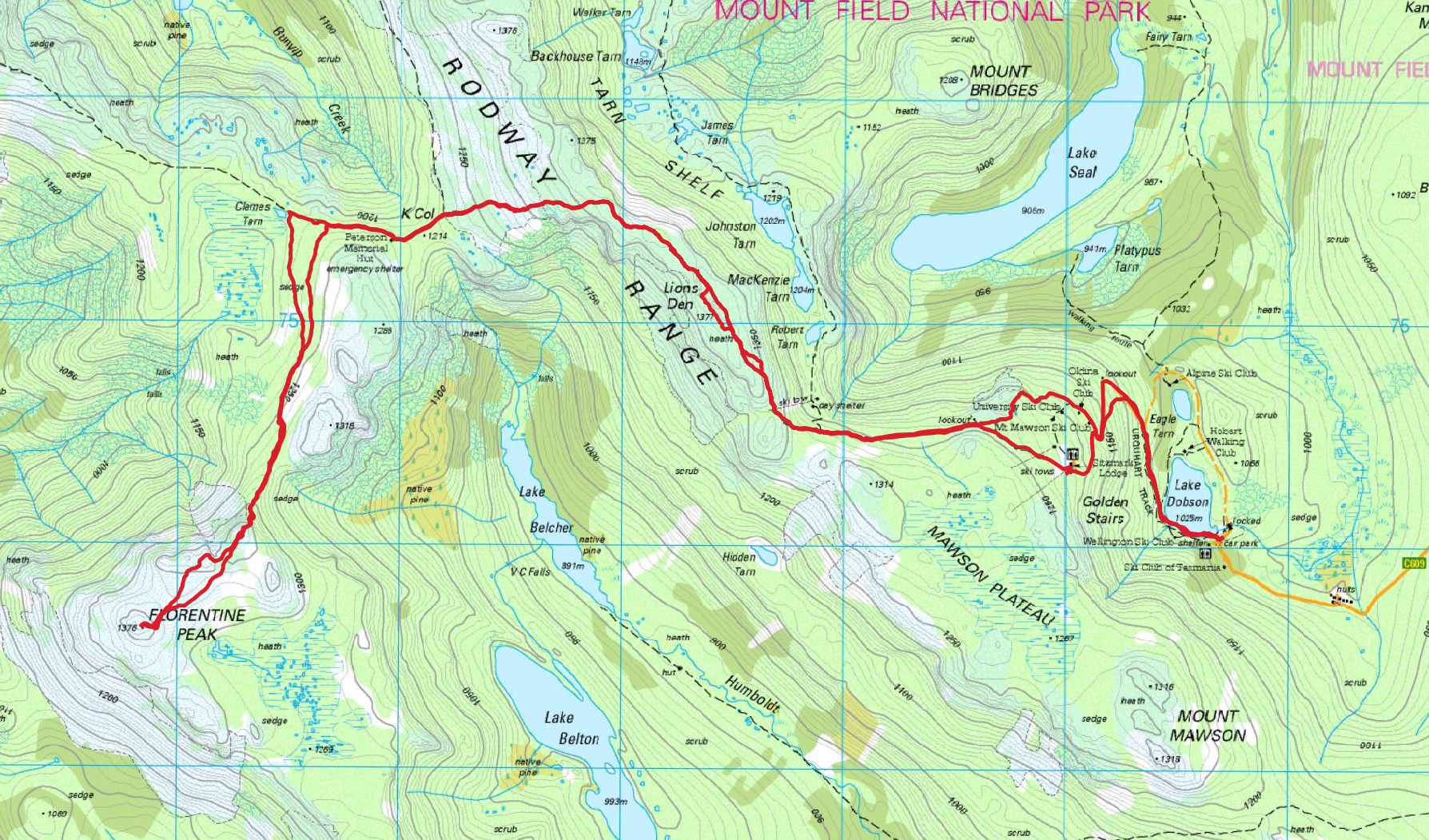
Rough timings (your milage may vary):
- About 1:25 from the car park to Rodway Range high point
- 1:10 from Rodway Range to Clemes Tarn
- 45 minutes from Clemes Tarn to Florentine Peak
- 2:30 from Florentine Peak back to car park